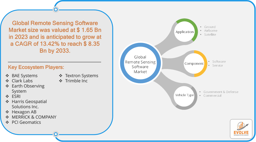
Evolve Business Intelligence has published a research report on the Global Remote Sensing Software Market, 2023–2033. The global Remote Sensing Software Market is projected to exhibit a CAGR of around 13.42% during the forecast period of 2023 to 2033.
Evolve Business Intelligence has recognized the following companies as the key players in the global Remote Sensing Software Market: BAE Systems, Clark Labs, Earth Observing System, ESRI, Harris Geospatial Solutions Inc., Hexagon AB, MERRICK & COMPANY, PCI Geomatics, Textron Systems and Trimble Inc.
 More Information: https://evolvebi.com/report/remote-sensing-software-market-analysis/
Market Highlights
The Global Remote Sensing Software Market is projected to be valued at USD 8.35 Billion by 2033, recording a CAGR of around 13.42% during the forecast period. The Remote Sensing Software Market refers to the industry segment focused on the development, distribution, and application of software tools that facilitate the processing, analysis, and interpretation of data captured through remote sensing technologies. Remote sensing involves the collection of information about an object or area from a distance, typically using satellite, aerial, or drone-based sensors. This software is essential for managing and analyzing vast amounts of data collected from these sensors, which can include imagery, environmental data, and other spatial information.
The growth of the Remote Sensing Software Market is driven by the rising demand for accurate geospatial information, advancements in sensor technologies, and the increasing adoption of remote sensing across various sectors for data-driven decision-making.
The COVID-19 pandemic had a significant impact on the Remote Sensing Software Market. The pandemic caused disruptions in the global supply chain, affecting the production and delivery of hardware components necessary for remote sensing systems, which in turn impacted the software market. Delays in satellite launches and other remote sensing infrastructure projects slowed the adoption of new software solutions. The need for remote monitoring and analysis became more critical during the pandemic, as organizations sought ways to maintain operations and manage resources without physical presence. Remote sensing software played a key role in monitoring environmental changes, tracking the spread of the virus, and supporting disaster management efforts. Remote sensing software was utilized to monitor environmental changes related to the pandemic, such as reduced pollution levels and changes in land use. The pandemic accelerated the digital transformation of many industries, leading to increased adoption of cloud-based remote sensing software solutions. The shift to remote work and the need for remote collaboration tools drove demand for cloud-based geospatial analysis and data sharing platforms.
Segmental Analysis
The global Remote Sensing Software Market has been segmented based on Application, Component and Vehicle Type.
Based on Application, the Remote Sensing Software Market is segmented into Ground, Airborne and Satellite. The Satellite segment is anticipated to dominate the market.
Based on Component, the global Remote Sensing Software Market has been divided into Software and Service. The Software segment is anticipated to dominate the market.
Based on Vehicle Type, the global Remote Sensing Software Market has been divided into Government & Defense and Commercial. The Commercial segment is anticipated to dominate the market.
More Information: https://evolvebi.com/report/remote-sensing-software-market-analysis/
Regional Analysis
The Remote Sensing Software Market is divided into five regions: North America, Europe, Asia-Pacific, South America, and the Middle East, & Africa. North America, particularly the United States, is a leading market for remote sensing software, driven by strong demand in sectors like defense, agriculture, environmental monitoring, and disaster management. The region benefits from advanced technological infrastructure, high R&D investment, and the presence of major players in the remote sensing software industry. Europe has a strong emphasis on environmental sustainability, climate change mitigation, and renewable energy, driving the adoption of remote sensing software for monitoring and regulatory compliance. The European Union supports the market through initiatives like the Copernicus Programme, which provides high-quality satellite data for various applications, including urban planning, agriculture, and disaster management. The Asia-Pacific region is experiencing rapid growth in the remote sensing software market, driven by increasing investments in infrastructure, agriculture modernization, and urbanization. Countries like China, India, and Japan are leading in the adoption of remote sensing technologies, with government initiatives focused on smart cities, disaster management, and environmental monitoring. Latin America’s economy, heavily reliant on agriculture and natural resources, drives the demand for remote sensing software to monitor crop health, deforestation, and environmental changes. The Middle East’s focus on oil and gas exploration and Africa’s rich natural resources create opportunities for remote sensing software in resource management, environmental monitoring, and land use planning. In Africa, remote sensing software is increasingly used for disaster management (e.g., drought monitoring) and agriculture, addressing food security concerns.